
This plan would play a key role in developing 40km of both banks of the Red River towards a modern, civilised capital for the 100 million people living in the country, said Pham Quang Nghi, Ha Noi Party committee secretary.
The plan’s estimated cost of US$7 billion will be spent on four development areas, including more than 2,000ha of land for an urban zone, a commerce and trading area, public land and a land fund for international festivals and sports events.
The plan includes flood-control measures based on South Korea’s construction model around the Han River.
The plan would ensure floodwater drainage, sustainable socio-economic development in line with environmental protection and a focus on green space, said To Anh Tuan, director of the Ha Noi Planning and Architecture Department.
Before being discussed at the conference, scientists, experts and Ha Noi residents all gave their opinions on the plan, said Le Van Hoat, head of the Economic Committee of the municipal People’s Council.
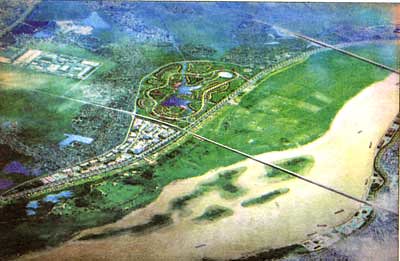
Detailed plan
If the plan is put into action, the river will be widened under the Thang Long bridge and north of the Chuong Duong bridge. The river will also be narrowed at some sections to ensure it is 4,200 metres across at its widest and 1,300 metres at its narrowest.
The readjustment of the river beds would improve flood drainage and make it easier to transport goods and use the river for tourism services, said Tuan.
In addition, a new system of stone embankments and dykes would be built to avoid land erosion, said Tuan.
Under the plan, 12 environmental and cultural preservation areas and 59 other projects including green space, pedestrian walkways, parking lots, entertainment centres, and a sports stadium will be built along the banks of the Red River.
The projects will be integrated and connected with the rest of the city.
The urban zones, which will include trade and commercial centres, will be set up in conformity with traditional craft villages.
However, the Ha Noi Party committee secretary reminded relevant authorities to be aware of public opinion and consult experts since the plan would have enormous consequences for the 170,000 people who are now living along the banks of the Red River.
It would be necessary to have suitable policies to relocate households, Nghi said.
About 4,500 households living between Chem and the Thang Long bridge will be relocated by 2012. About 23,900 households living from the Thang Long bridge to the Thanh Tri bridge will be relocated between 2013 and 2016, and 6,700 between the Thanh Tri bridge and the Bat Trang Pottery village from 2016 to 2020.
Opinions from experts and citizens:Pham Si Liem, Viet Nam Federation of Civil Engineering Associations deputy chairman: "The plan’s proposed start is likely to coincide with the transformation of living along the Red River. However, the number of people on either bank of the river will increase quickly when more bridges are built. The later the project starts, the more difficult site clearance will become. It should be done soon."
Le Thi Thuy Van, Academy of Finance, expert: "The project will cost a large sum of money, so authorities need to take more practical measures. For example, using the Red River for tourism is impractical because during the dry season, the river doesn’t have enough water for boats."
Nguyen Minh Trang, a citizen in Tay Ho district: "It is necessary to have suitable policies for the citizens who will be relocated, like us. [Authorities] must avoid a situation where relocation areas lack electricity, water or other facilities like schools or hospitals."
Pham Van Quang, deputy director of the Geology Environment Institute: "[Authorities] should do surveys of geology in the area before creating a detailed plan to avoid landslides along the river banks."
Source: Viet Nam News
Post a Comment
Post a Comment