
VNRE - The master plan for the Gia Lam area is based on a desire to retain the qualities and resources of the area, but at the same time set out the strategies for a natural and sustainable urban growth. The plan recognises the importance of securing a continuity for the local community in the turbulent process of developing and modernizing the area.

Topological concepts
A robust and distinct urban topology is essential for the successful creation of a community, to which the inhabitants can relate, feel at home and feel pride in belonging to. The urban structure is the blueprint for creating secure and inviting, but interconnected neighbourhoods. The guiding boundaries between interrelated structures is what gives the city its identity and uniqueness. This master plan for Gia Lam is based on a set of robust guidelines, called topological guides.
Structural concepts
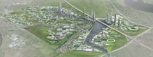
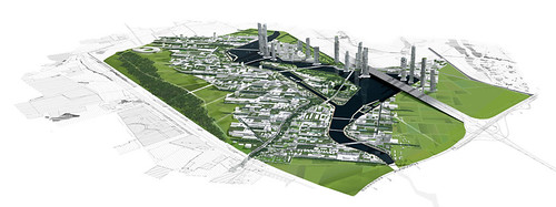
The combination of two distinctly different urban structures are used on the site. To the NE, between the river and the hills, a low-dense urban structure wraps around the original village and creates an urban mesh with an overweight of housing and social functions. The low-dense area is rather rigid in its general structure, but variation and interesting and unexpected spatial experiences are created by a flexible set of planning rules for the area. To the SW, between the river and the lowlands, a different kind of urban landscape is created by a high variation of high-rise and low-rise. This part of the city has a different distribution of functions with an overweight of commercial and office use. The dialogue between the urban structures over the river creates a spatial entity catering for the needs and moods of all individuals.
For both the low-dense and the high-rise areas a rating system like BREEAM or LEAD should be used for the general assessment of sustainable construction.
Urban sustainability concepts
Traffic/secure environment
Efficient public transport and the reduction of car traffic is the single most important factor in creating a sustainable community. The Gia Lam master plan is created around a public transport system, where a local tramline is connected to the existing train station with connections to Hanoi. The Master plan assumes the existing station North of the site to be the future traffic hub, but the tram line can be redirected to connect to other future stations. A tram system is chosen, as the visibility in the urban space encourages use and the economy is more favourable than a metro.
Eco-corridors and water management
The recreational areas on either side of the developments are connected to the river area by a series of elongated parks or eco-corridors. These corridors secures the un-interrupted migration of species and flow of water between the natural areas and thus supports a continuous eco-system. The corridors are also part of the general water management strategy.
A sustainable urban drainage system is created in order to manage storm water runoff by means of slow release and storage systems such as green roofs and ponds in park areas. This enables water to remain “in nature” and not place loads on treatment works and to minimise sediment/contamination load to streams. Reed bed treatment ensures purification.
Grey water recycling is encouraged to save potable water as well as water minimisation features such as monitoring of use.
Energy and waste management
The primary strategy in terms of energy lies in energy savings. Only after using all measures to ensure a low energy consumption by reducing the need for transport, cooling and lighting is it viable to invest in local energy production. A couple of energy producing measures is at hand though. High buildings in the southern area can use building-integrated wind turbines, and solar shading of the facades can be combined with PV-panels. Adsorption coolers combined with water-based solar collectors can provide cooling for office buildings. In the low northern part of the development, local solar collectors can be used for hot water production for the individual buildings. On a regional scale, the waste water treatment can power itself from the biogas it is generating.
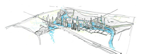
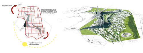
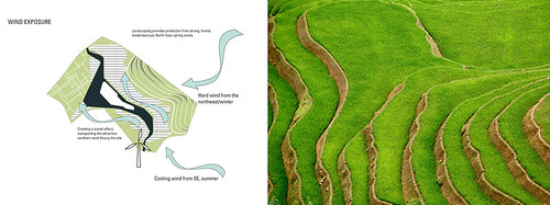
The proposed masterplan is derived from a climatic analysis as well as the urge to create a distinct and recognizable urban typology. The canal on the site is redirected and used as a guiding topographic feature, creating a focus and a recreational core element. The altered canal now runs in the NW-SE direction, orientating the urban structure in the same direction and opening the plan towards NW and SE. Toward NE, the development is topologically more closed, protected by a hilly recreational landscape. With this main lay-out, the urban fabric is relatively protected from the prevailing winter winds, but opening up for the cooling summer breezes from SE. This orientation is seen on a smaller scale as well within the housing structure itself. This main layout creates a set of different urban and ecological typologies, arranged in bands, but connected via “corridors”, running perpendicular to the main orientation. The distinct urban typology is emphasized in the central island, housing the most important parts of the university and thus using this as an identifying core of the development.
- Location: Gia Lam, Hanoi province, Vietnam
- Area: 12.000.000m2
- Client: VIDIFI; Vietnam Development Bank; Bank for Foreign Trade of Vietnam; Vinaconex R&D
- Architect: DISSING+WEITLING architecture; Vinaconex R&D
- Engineer: Buro Happold (UK)
- Illustrations/Renderings: DISSING+WEITLING architecture
Topological concepts
A robust and distinct urban topology is essential for the successful creation of a community, to which the inhabitants can relate, feel at home and feel pride in belonging to. The urban structure is the blueprint for creating secure and inviting, but interconnected neighbourhoods. The guiding boundaries between interrelated structures is what gives the city its identity and uniqueness. This master plan for Gia Lam is based on a set of robust guidelines, called topological guides.
Structural concepts
The combination of two distinctly different urban structures are used on the site. To the NE, between the river and the hills, a low-dense urban structure wraps around the original village and creates an urban mesh with an overweight of housing and social functions. The low-dense area is rather rigid in its general structure, but variation and interesting and unexpected spatial experiences are created by a flexible set of planning rules for the area. To the SW, between the river and the lowlands, a different kind of urban landscape is created by a high variation of high-rise and low-rise. This part of the city has a different distribution of functions with an overweight of commercial and office use. The dialogue between the urban structures over the river creates a spatial entity catering for the needs and moods of all individuals.
For both the low-dense and the high-rise areas a rating system like BREEAM or LEAD should be used for the general assessment of sustainable construction.
Urban sustainability concepts
Traffic/secure environment
Efficient public transport and the reduction of car traffic is the single most important factor in creating a sustainable community. The Gia Lam master plan is created around a public transport system, where a local tramline is connected to the existing train station with connections to Hanoi. The Master plan assumes the existing station North of the site to be the future traffic hub, but the tram line can be redirected to connect to other future stations. A tram system is chosen, as the visibility in the urban space encourages use and the economy is more favourable than a metro.
Eco-corridors and water management
The recreational areas on either side of the developments are connected to the river area by a series of elongated parks or eco-corridors. These corridors secures the un-interrupted migration of species and flow of water between the natural areas and thus supports a continuous eco-system. The corridors are also part of the general water management strategy.
A sustainable urban drainage system is created in order to manage storm water runoff by means of slow release and storage systems such as green roofs and ponds in park areas. This enables water to remain “in nature” and not place loads on treatment works and to minimise sediment/contamination load to streams. Reed bed treatment ensures purification.
Grey water recycling is encouraged to save potable water as well as water minimisation features such as monitoring of use.
Energy and waste management
The primary strategy in terms of energy lies in energy savings. Only after using all measures to ensure a low energy consumption by reducing the need for transport, cooling and lighting is it viable to invest in local energy production. A couple of energy producing measures is at hand though. High buildings in the southern area can use building-integrated wind turbines, and solar shading of the facades can be combined with PV-panels. Adsorption coolers combined with water-based solar collectors can provide cooling for office buildings. In the low northern part of the development, local solar collectors can be used for hot water production for the individual buildings. On a regional scale, the waste water treatment can power itself from the biogas it is generating.
The proposed masterplan is derived from a climatic analysis as well as the urge to create a distinct and recognizable urban typology. The canal on the site is redirected and used as a guiding topographic feature, creating a focus and a recreational core element. The altered canal now runs in the NW-SE direction, orientating the urban structure in the same direction and opening the plan towards NW and SE. Toward NE, the development is topologically more closed, protected by a hilly recreational landscape. With this main lay-out, the urban fabric is relatively protected from the prevailing winter winds, but opening up for the cooling summer breezes from SE. This orientation is seen on a smaller scale as well within the housing structure itself. This main layout creates a set of different urban and ecological typologies, arranged in bands, but connected via “corridors”, running perpendicular to the main orientation. The distinct urban typology is emphasized in the central island, housing the most important parts of the university and thus using this as an identifying core of the development.
- Location: Gia Lam, Hanoi province, Vietnam
- Area: 12.000.000m2
- Client: VIDIFI; Vietnam Development Bank; Bank for Foreign Trade of Vietnam; Vinaconex R&D
- Architect: DISSING+WEITLING architecture; Vinaconex R&D
- Engineer: Buro Happold (UK)
- Illustrations/Renderings: DISSING+WEITLING architecture
Post a Comment
Post a Comment